


| (CFMS-DC) v 1.0 (Old Version) | (CFMS-DC) v2.0 | ||
| (CFMS-DC) Police Admin | (CFMS-DC) v2.0 Link-2 | ||
| (CFMS-DC) v2.0 Link-3 | Search Cases | ||
| (CFMS-DC) Electronic
Surety Verification System (eSVS-DC) |
Police FIR module |
MOUNTAIN & HISTORICAL PLACES
District Tharparkar is also rich in versatile and diversified monuments and historical places. The following are a few of the places which are worth seeing.
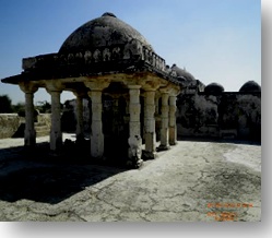
Naukot Fort (Naukot jo Qilo نئون ڪوٽ جو قلعو )
 There is Naukot Fort locally called as “Naukot jo Qilo”, which was constructed by Talpur dynasty established by Mir Karam Ali Khan Talpur in 1814. The fort of Naukot is situated at around 43 kilometers away from Taluka Mithi, on the Mithi to Naukot road, at around 5 kilometers away from Naukot Town. Its location gave it its other common name, "The Gateway to the Thar Desert". It is meant to guard the area against the Rajputs.
==========================================================================
G A D D I (Bhit) Mithi
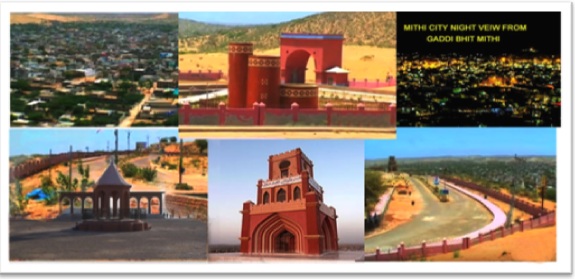 Gadi -Bhit is by far the only attraction in town thus is most visited and popular site of the town. It is the highest elevation point of the town built on a sand-hill and gives a breathtaking panoramic view of the Mithi town. In the holidays and weekend the peoples with their children and family enjoying to visit this bhit also mostly visitors attracted to see this beautiful sight view of Town.
==========================================================================
Gadi -Bhit is by far the only attraction in town thus is most visited and popular site of the town. It is the highest elevation point of the town built on a sand-hill and gives a breathtaking panoramic view of the Mithi town. In the holidays and weekend the peoples with their children and family enjoying to visit this bhit also mostly visitors attracted to see this beautiful sight view of Town.
==========================================================================
Gori Temple (Gori Jo Mandar گوري جو مندر)
 There is also one temple called Gori Jo Mandar (Gori Temple), which is situated approximately 90 kilometers away from Mithi, at Islamkot to Nangarparkar road. According to historians, this temple was constructed by the Jain followers, reportedly in 300 A.D. The Gori temple was constructed using carved stones of marble. The Gori temple is a very beautiful site to visit. It has 52 steeples and there are also small rooms into it, which probably were for the worshipers. This monument is one of its kinds and looks fabulous.
==========================================================================
There is also one temple called Gori Jo Mandar (Gori Temple), which is situated approximately 90 kilometers away from Mithi, at Islamkot to Nangarparkar road. According to historians, this temple was constructed by the Jain followers, reportedly in 300 A.D. The Gori temple was constructed using carved stones of marble. The Gori temple is a very beautiful site to visit. It has 52 steeples and there are also small rooms into it, which probably were for the worshipers. This monument is one of its kinds and looks fabulous.
==========================================================================
Well of Marvi at Village Bhalwa (مارئي جو کو)
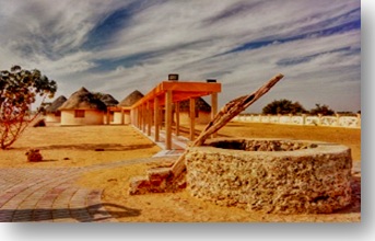 Bhalwa is the local village of Marvi and the area is also historical known as malir. Marvi is considered as the daughter of desert Thar, who is a symbol of patriotism and chastity. The noticeable place to visit is a well, situated near village Bhalwa, from where King Umer had forcibly taken away Marvi, but she refused the life of Queen and to marry King Umer, for her parents and her people. The village Bhalwah is situated at the approximate distance of 93 kilometers from the district headquarter Mithi, and is situated on the road from Islamkot to Nangarparkar.
==========================================================================
Bhalwa is the local village of Marvi and the area is also historical known as malir. Marvi is considered as the daughter of desert Thar, who is a symbol of patriotism and chastity. The noticeable place to visit is a well, situated near village Bhalwa, from where King Umer had forcibly taken away Marvi, but she refused the life of Queen and to marry King Umer, for her parents and her people. The village Bhalwah is situated at the approximate distance of 93 kilometers from the district headquarter Mithi, and is situated on the road from Islamkot to Nangarparkar.
==========================================================================
Bhodesar Mosque
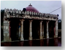 The remains of Bhodesar are situated at the distance 3 kilometers away from Nangarparkar beneath Karoonjhar hills. The history shows that this town was once known as Bhodesar nagri, and there ruled one Queen named “Bhodi”. According to historians, Sultan Mehmood Begra constructed a beautiful mosque at this place in the year 1505. There are also some remains of three ancient Jain structures, which were supposed to have been built in 1375 and 1449 A.D.
===========================================================================
Churrio Mountain
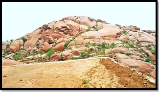 Churrio Mountain (چوڙيو جبل) is a hill, named Churrio, located in Taluka Nangarparkar, district Tharparkar. A few scores from the Taluka headquarters, the hill is located at the outermost border of the country in the south-east of the province, surrounded by India from three sides, primarily famous for three things: the valuable multi-colored granite hill, the historical bangles' business and the temple of goddess Durga that attracts pilgrims from the international community following Hinduism. The name Churrio (Choryo) is a word from Sindhi language, derived from a word (چوڙي), to be pronounced as (Choo-rree), which means 'a bangle' thus the word Churrio - an adjective in Sindhi language - means "belonging to/related to bangles", because in the vicinity of the hill there are a number of small villages that have historically remained attached to the profession of manufacturing bangles for women.
===========================================================================
Churrio Durga
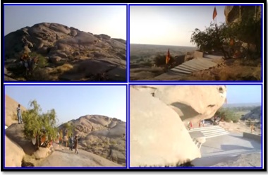 The Churrio Hill is formed of granite. The geological colour formation of granite is usually grey, the granite colour formation in Churrio, out of 8 to 10 varieties of pink and grey, is multicoloured; hence, pretty expensive, and is accordingly used in buildings, bridges, paving monuments and other exterior projects. On the top of this Churrio Hill is a temple of goddess Durga, a goddess of Hinduism, attributed as destroyer of evil, triumph of good over evil, the mother of universe, and power behind the creation, preservation, and destruction of the world. Owing to Durga's temple, thousands of pilgrims.
===========================================================================

Quick Links